
The forecast for the 2024 hurricane season is the most aggressive on record, with the possibility of up to 25 named storms and 13 hurricanes.
This record forecast dates all the way back to when the National Oceanic and Atmospheric Administration (NOAA) and Colorado State University (CSU) first began issuing outlooks in 1998 and 1984 respectively.
A combination of record breaking oceanic warmth and a swift transition from a strong El Niño to a La Niña are setting the stage for what could be a record-breaking hurricane season, and the meteorological community is becoming increasingly concerned.
“The tropical Atlantic is like a powder keg this year, storing an immense quantity of fuel for hurricanes as it experiences record warm sea surface temperatures,” said Joshua Feldman, Head of Meteorology at WeatherOptics.
“Without wind shear to disrupt hurricane circulations due to a La Niña summer, tropical cyclones will be frequent and have a propensity for both longevity and rapid intensification.” Feldman continued.
Hurricane prone communities need to pay close attention, and businesses need to make sure they have an action plan with the proper weather risk and impact tools.

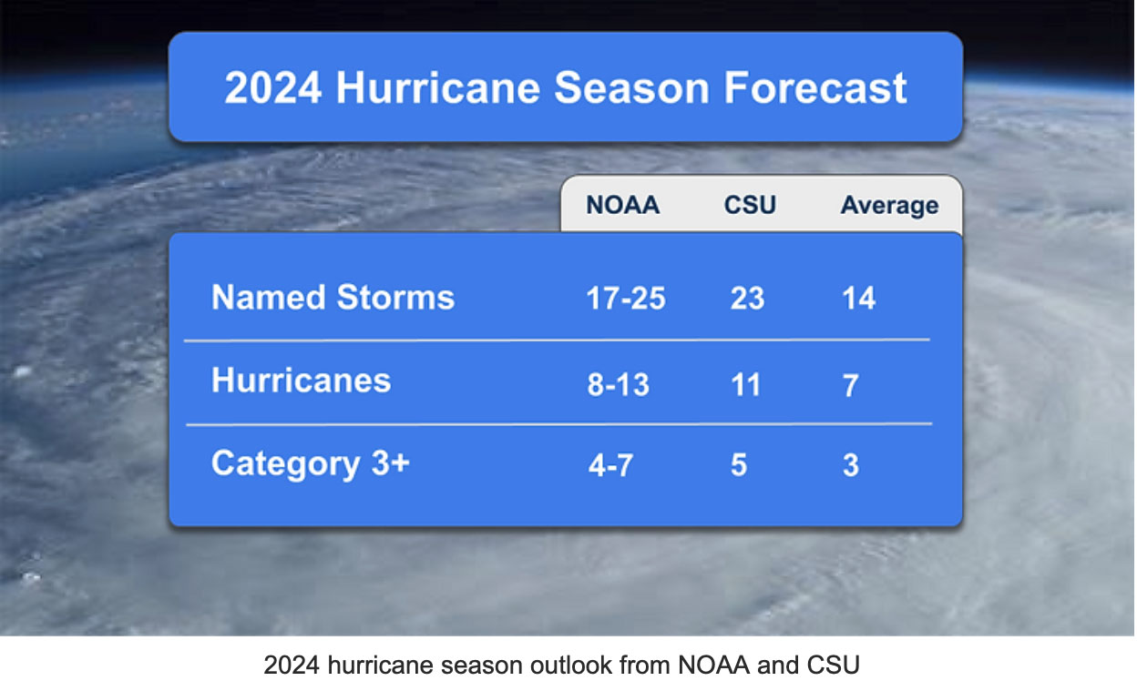
NOAA’s Outlook: The agency is predicting an 85% chance of an above-average season, which would be the 8th above average season in the last 10 years. Here’s a breakdown:
Named Storms: 17-25
Hurricanes: 8-13
Major Hurricanes (Cat 3+): 4-7
CSU Outlook: The university is predicting a similar highly active season, along with much higher odds of a major hurricane hitting the U.S, which includes a 42% chance for the Gulf Coast.
Named Storms: 23
Hurricanes: 11
Major Hurricanes (Cat 3+): 5
Compared to an average hurricane season (1991-2020) which typically features 14 named storms, 7 hurricanes, and 3 major hurricanes, NOAA and CSU are predicting an 85% and 57% increase respectively in the number of hurricanes for 2024.
The CSU hurricane forecasting team, led by Dr. Phil Klotzbach, is considered one of the best for long range hurricane predictions.
They forecast using a statistical model that leverages 40+ years of past Atlantic hurricane statistics, along with dynamical model output from four major NWP agencies: ECMWF, UKMET, JMA, and CMCC.
2024 is the most aggressive forecast they have ever issued in the 30 years the team has been producing pre-season outlooks. Forecast confidence is also unusually high.
Based on their modeling, CSU predicts a higher than normal chance of a major hurricane hitting the U.S. coastline compared to average. Here’s the breakdown:
Overall Chances of landfall: 62% (average 43%)
East Coast or Florida Peninsula Chances: 34% (average 21%)
Gulf Coast: 42% chance (average 27%)
Caribbean: 66% chance (average 47%)
There are several key factors that have meteorologists concerned about the upcoming hurricane season:
A quick transition from El Nino to La Nina
According to NOAA’s Climate Prediction Center, there is an 83% chance that the current El Nino dissipates by June, and a 62% chance that La Nina conditions develop between June and August. El Niño and La Niña are the warm and cool phases of the recurring ocean-atmospheric pattern in the equatorial Pacific known as ENSO — El Niño Southern Oscillation.
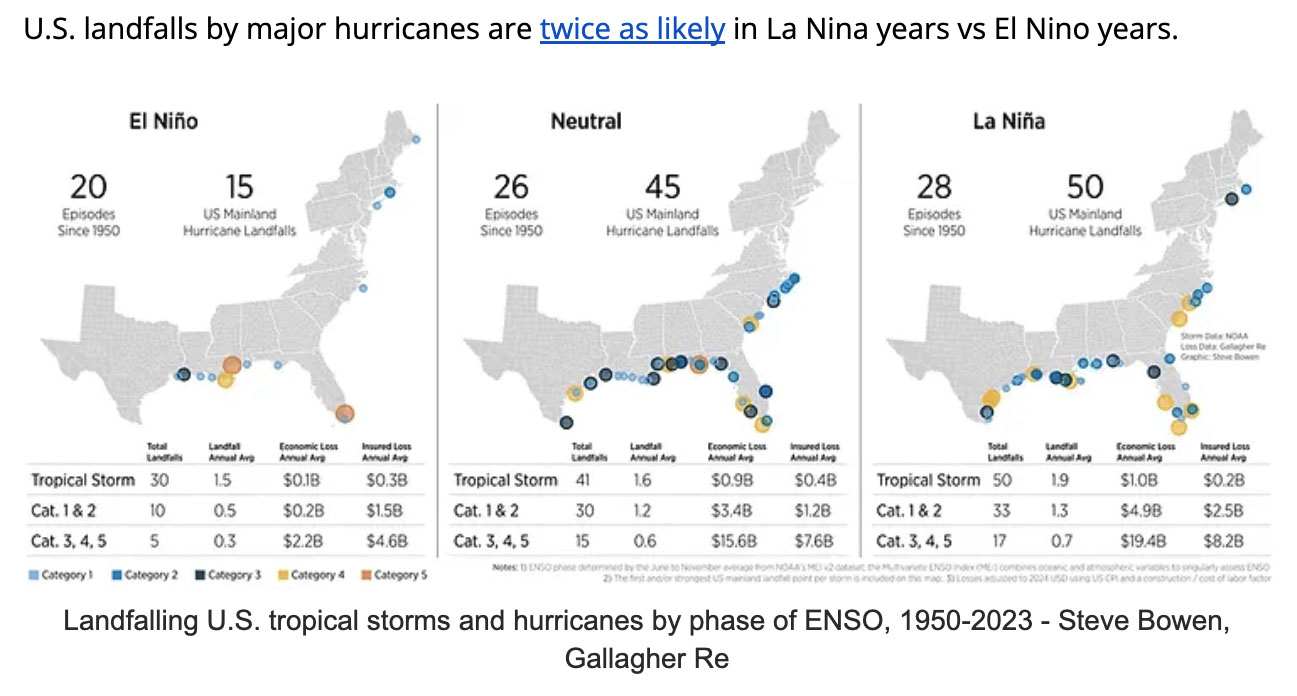
La Nina typically leads to a more active hurricane season by relaxing vertical wind shear, which can tear hurricanes apart and inhibit development throughout the Atlantic Basin.
U.S. landfalls by major hurricanes are twice as likely in La Nina years vs El Nino years.
Record-warm ocean temperatures
We are in new territory heading into the start of hurricane season 2024.
The Atlantic Basin has never experienced the level and coverage of record breaking sea surface temperatures like we’re currently witnessing. Nearly 90% of the Atlantic Basin is at or above record breaking temperatures.
The current ocean temperatures are far ahead of the previous record holder set in 2005, a year known as one of the most active and destructive hurricane seasons on record.
The most concentrated area of abnormal heat is across the Caribbean, where water temperatures are already warmer than the normal seasonal peak – a temperature that isn’t typically hit until September.
Waters right now are averaging 84.7 degrees Fahrenheit, a weekly temperature that has never been observed before August, with some stations off the Florida Keys nearing 90 degrees Fahrenheit as we kick off June.
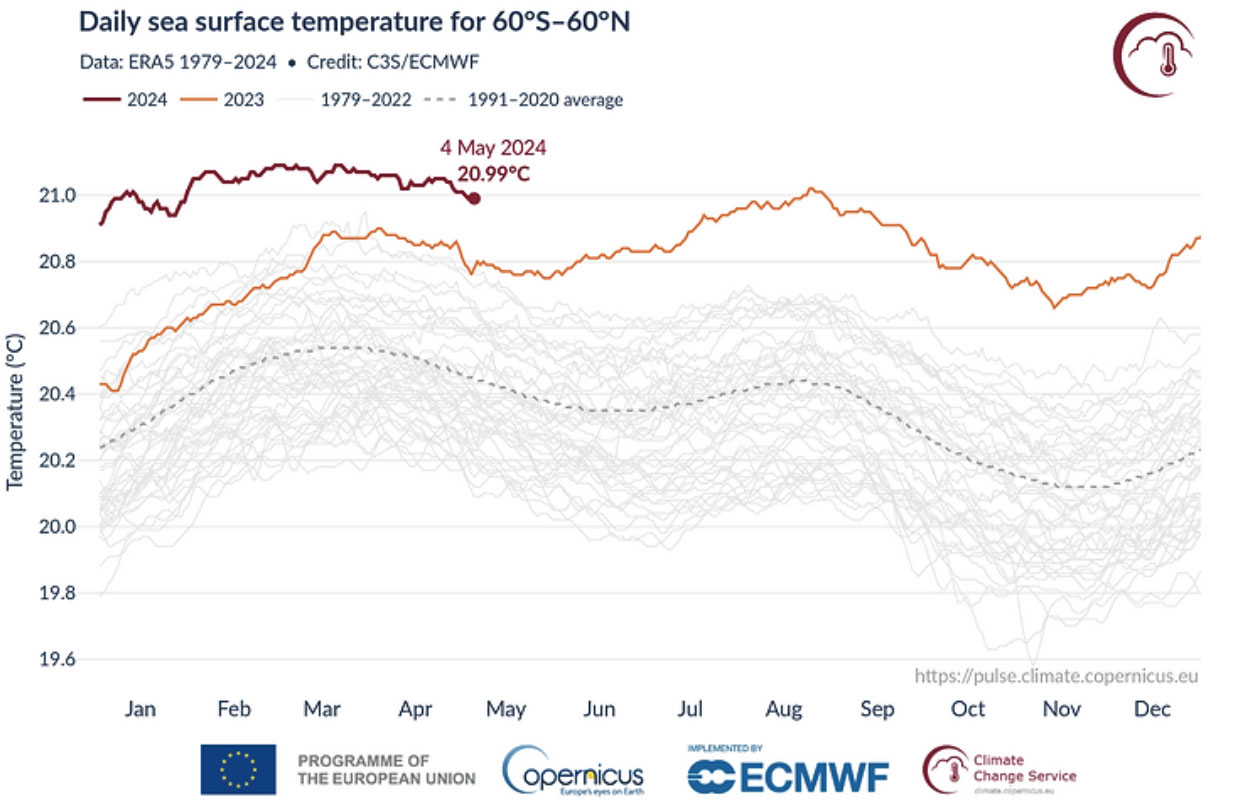
Daily sea surface temperature (°C) averaged over the extra-polar global ocean (60°S–60°N) for 2023 (orange) and 2024 (dark red). All other years between 1979 and 2022 are shown with grey lines. Data source: ERA5. Credit: Copernicus Climate Change Service/ECMWF.
Hurricanes are becoming more frequent and stronger
Overall we’ve been seeing a trend since the 1970s and 1980s of more named storms and an increased number of major hurricanes.
The average number of major hurricanes (category 3+) in the 2000s and 2010s was 3.1-3.8 per year, compared to the 1970s and 1980s when the average was only 1.6 per year.
While we haven’t had a named storm yet in the 2024 season, there has also been an increased trend in tropical systems forming earlier than normal.
In 8 of the past 10 years, tropical storms have formed in the Atlantic Basin before the official start of hurricane season on June 1.
What an active season means for businesses and communities
The hyperactive hurricane season poses multiple risks for different business verticals, especially those in emergency management, supply chain, logistics, and trucking. Towns and cities in hurricane prone areas should prepare for the season ahead of time. Here are some of the most common impacts we see from landfalling hurricanes:
Disrupted supply chain and logistics operations
- Transportation delays: Hurricanes can lead to significant delays in transportation due to road closures, port shutdowns, and disruptions to air and rail services. This can delay the delivery of goods, affecting inventory and leading to stockouts or overstock situations.
- Route changes & increased operation costs: Businesses may need to reroute shipments to avoid affected areas, which often leads to increased fuel costs and longer delivery times. This can result in higher operational costs and impact the efficiency of logistics operations.
- Labor and workforce challenges: Severe weather can prevent employees from reaching work, especially in transportation and warehousing. This can slow down operations and significantly reduce productivity.
- Facility damage: Hurricanes can cause extensive damage to warehouses, distribution centers, manufacturing plants, and even office buildings. Businesses may face costly repairs and interruptions in their operations while they rebuild or relocate.
- Power outages: Hurricanes can wreak havoc on power lines and cause widespread outages that last for days or even weeks. This can halt production, spoil perishable goods, and disrupt communications. Backup power solutions may help, but can be costly to implement and maintain, and they may not last for the necessary time.
- Communication disruptions: Damage to communication infrastructure can make coordination and information flow difficult for emergency managers. It can also further interrupt the supply chain, exacerbating delays and inefficiencies.
Drastic swings in supply and demand
- Pre-hurricane surge in demand: We often see a surge in demand for essential goods such as food, water, fuel, and building material before a hurricane strikes. Businesses need to be prepared to meet this spike in demand to maintain customer satisfaction and capitalize on sales.
- Post hurricane supply shortages: Hurricanes have the potential to severely disrupt supply chains, leading to shortages of goods and materials. Businesses may struggle to restock inventory to meet the sudden surge in demand, particularly for building supplies and material.
- Fluctuations in consumer behavior: Consumer behavior tends to shift before, after, and during hurricanes. We often see an increase in demand for critical goods and supplies, and a significant decrease in demand for non-essential items. It can be difficult for businesses to navigate and adapt their inventory and sales strategies to remain competitive.
How WeatherOptics & WebEOC are working together to improve emergency preparedness and response
WeatherOptics is designed for businesses to make smarter decisions before, during, and after high impact weather events like hurricanes.
Our proprietary AI weather modeling improves forecast accuracy by up to 50% during severe weather events, and feeds into our suite of impact risk scores, intelligent routing, and hyperlocal weather products.
The WeatherOptics Insight Portal and APIs can help your business navigate the upcoming hurricane season by notifying your team ahead of time when critical operations are expected to be impacted, what actions should be taken, and where damage was recorded.
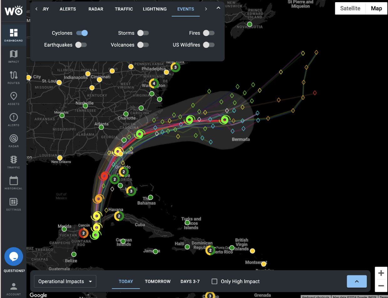
WeatherOptics Insight Portal leading up to Hurricane Idalia in 2023. Forecast track + Road Index for Tampa Bay, FL.
Actionable impact intelligence: Enterprise businesses can use WeatherOptics’ 0-10 impact risk scores to understand how key business operations are going to be affected by weather. This includes our Road Conditions Index, Power Outage Index, Life & Property Index, Flood Index, Businesses Disruption Index, and more.
Shipment and transportation optimization: Shippers, carriers, and supply chain companies can leverage our market leading RightRoute software to predict impacts on key shipments, lanes, and truck routes days in advance. The tool predicts delay times, road risk, and alternative routing options for smoother and safer transportation.
Storm damage reports: Emergency managers can quickly identify what areas have been hit hardest by a hurricane and where the most support is needed by seeing real-time storm damage reports.
Customized deliverables to meet your needs: Every business is different, and WeatherOptics can offer access to our insights in a variety of ways. This includes our Enterprise Resilience Insight Portal, APIs, Alerts, and automated AI briefings on Critical Events.